


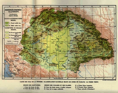
Treitz, Péter (Kartográfus): Magyarország klimazonális talajtérképe. (1924)
![[img]](http://real-i.mtak.hu/1074/1/b3147_gistt_treitz_terkep.JPG)
|
Kép
b3147_gistt_treitz_terkep.JPG Letöltés (345kB) | Előzetes bemutató |
|
![[img]](http://real-i.mtak.hu/1074/2/b3147_gistt_treitz_magyarazo.JPG)
|
Kép
b3147_gistt_treitz_magyarazo.JPG Letöltés (180kB) | Előzetes bemutató |
| Tétel típus: | Térkép | ||||||
|---|---|---|---|---|---|---|---|
| További információk: | In: Magyarázó az országos átnézetes klimazonális talajtérképhez / szerk: Treitz Péter. – Budapest : M. Kir. Földtani Intézet, 1924 . – 47 p : ill ; 28 cm | Treitz Péter (1866-1935) -- agrogeológus, a magyar gazdasági talajtan megalapítója | ||||||
| Szabad kulcsszavak: | talajtan -- talajtérképezés, felvételezés, talajinformációs rendszer | ||||||
| Szakterület(ek): | Q Science / természettudomány > QE Geology / földtudományok S Agriculture / mezőgazdaság > S1 Agriculture (General) / mezőgazdaság általában > S590 Soill / Talajtan |
||||||
| Intézmények: | MTA TAK Talajtani és Agrokémiai Kutatóintézet | ||||||
| Feltöltő: | László Sallai-Tóth | ||||||
| Alkotók: |
|
||||||
| Elhelyezés dátuma: | 22 Szep 2021 11:28 | ||||||
| Utolsó változtatás: | 22 Szep 2021 11:28 | ||||||
| URI: | http://real-i.mtak.hu/id/eprint/1074 |
Szerkesztés (Bejelentkezés szükséges)
 |
Tétel szekesztése |
