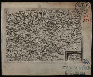
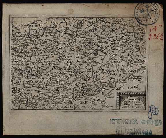
Hogenberg, Frans
(Kartográfus):
Hvngaria.
(1579)
| Tétel típus: |
Térkép
|
| További információk: |
OSZK Földabrosz:
P. Meurer az Itinerarium orbis Christiani ismertetőjében úgy véli, hogy a térképek metszője F. Hogenberg volt, de sem M. von Eitzing, sem J. Metellus szerzőségét nem tartja megalapozottnak
Kiadó / terjesztő: s.n.
Raktári szám: Térkép 52
Egyéb cím: Hungaria |
| Szabad kulcsszavak: |
Szántai Lajos, Magyarország, általános térkép |
| Szakterület(ek): |
G Geography. Anthropology. Recreation / földrajz, antropológia, kikapcsolódás > GA Mathematical geography. Cartography / földméréstan, geodézia, térképészet |
| Intézmények: |
MTA Könyvtár és Információs Központ > MTA KIK Kézirattár és Régi Könyvek Gyűjteménye |
| Feltöltő: |
Bálint Tóth
|
| Alkotók: |
| Közreműködés típusa | Név | Alkotó azonosító |
|---|
| Kartográfus | Hogenberg, Frans | MEGHATÁROZATLAN |
|
| Elhelyezés dátuma: |
20 Júni 2025 07:51 |
| Utolsó változtatás: |
12 Dec 2025 10:28 |
| URI: |
https://real-i.mtak.hu/id/eprint/18607 |
Szerkesztés (Bejelentkezés szükséges)
 |
Tétel szekesztése |


![[img]](https://real-i.mtak.hu/18607/1/Terkep_052.jpg)
![[img]](https://real-i.mtak.hu/18607/2/Terkep_052_H.jpg)
