


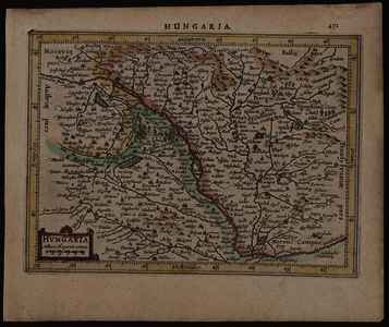
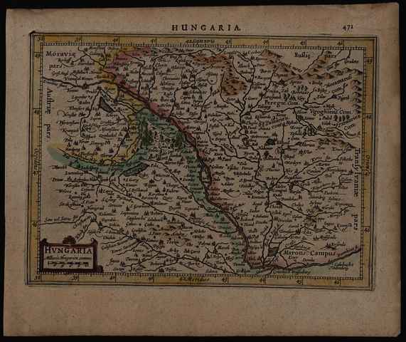
Mercator, Gerardus (Kartográfus): Hvngaria. (1634)
![[img]](https://real-i.mtak.hu/18723/1/Terkep_131.jpg)
|
Kép
Terkep_131.jpg Letöltés (2MB) | Előzetes bemutató |
|
![[img]](https://real-i.mtak.hu/18723/2/Terkep_131_H.jpg)
|
Kép
Terkep_131_H.jpg Letöltés (2MB) | Előzetes bemutató |
| Tétel típus: | Térkép | ||||||
|---|---|---|---|---|---|---|---|
| További információk: | OSZK Földabrosz: A Koeman’s Atlantes Neerlandici, 352. tétel leírása szerint (513. ol.) a J. Janssonius által 1628-tól kiadott Atlas minor c. atlaszok térképeit P. van den Keere és A. Goos metszette (utóbbi csak a világtérképet és a kontinenstérképeket) Kiadó / terjesztő: J. Janssonius Raktári szám: Térkép 131 Egyéb cím: Hungaria | ||||||
| Szabad kulcsszavak: | Szántai Lajos, Magyarország, általános térkép | ||||||
| Szakterület(ek): | G Geography. Anthropology. Recreation / földrajz, antropológia, kikapcsolódás > GA Mathematical geography. Cartography / földméréstan, geodézia, térképészet | ||||||
| Intézmények: | MTA Könyvtár és Információs Központ > MTA KIK Kézirattár és Régi Könyvek Gyűjteménye | ||||||
| Feltöltő: | Bálint Tóth | ||||||
| Alkotók: |
|
||||||
| Elhelyezés dátuma: | 24 Júni 2025 07:40 | ||||||
| Utolsó változtatás: | 12 Dec 2025 10:27 | ||||||
| URI: | https://real-i.mtak.hu/id/eprint/18723 |
Szerkesztés (Bejelentkezés szükséges)
 |
Tétel szekesztése |
