


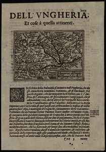
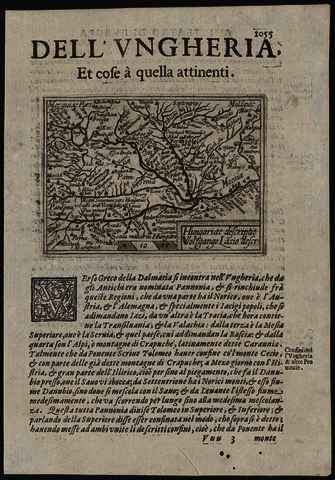
Galle, Filips (Egyéb): Hungariae descriptio. (1623)
![[img]](https://real-i.mtak.hu/18804/1/Terkep_201.jpg)
|
Kép
Terkep_201.jpg Letöltés (1MB) | Előzetes bemutató |
|
![[img]](https://real-i.mtak.hu/18804/2/Terkep_201_H.jpg)
|
Kép
Terkep_201_H.jpg Letöltés (1MB) | Előzetes bemutató |
| Tétel típus: | Térkép | ||||||
|---|---|---|---|---|---|---|---|
| További információk: | OSZK Földabrosz: Fokhálózat nélkül A térképnek csak ősforrása volt a W. Lazius által készített és 1556-ban megjelent országtérkép; valójában a F. Galle által Antwerpenben készített és kiadott Epitome c. kisatlasz lapját, vagy annak olasz, P. M. Marchetti-féle változatát másolták Kiadó / terjesztő: Presso Giacomo Sarzina Raktári szám: Térkép 201 | ||||||
| Szabad kulcsszavak: | Szántai Lajos, Magyarország, általános térkép | ||||||
| Szakterület(ek): | G Geography. Anthropology. Recreation / földrajz, antropológia, kikapcsolódás > GA Mathematical geography. Cartography / földméréstan, geodézia, térképészet | ||||||
| Intézmények: | MTA Könyvtár és Információs Központ > MTA KIK Kézirattár és Régi Könyvek Gyűjteménye | ||||||
| Feltöltő: | Bálint Tóth | ||||||
| Alkotók: |
|
||||||
| Elhelyezés dátuma: | 25 Júni 2025 13:07 | ||||||
| Utolsó változtatás: | 12 Dec 2025 10:27 | ||||||
| URI: | https://real-i.mtak.hu/id/eprint/18804 |
Szerkesztés (Bejelentkezés szükséges)
 |
Tétel szekesztése |
