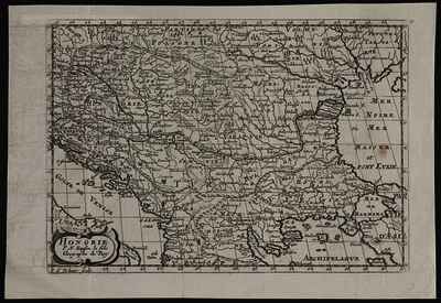
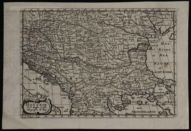
Hongrie
Sanson, Nicolas
(Kartográfus):
Hongrie.
(1734)
| Tétel típus: |
Térkép
|
| További információk: |
OSZK Földabrosz:
N. II Sanson készítette a térkép eredetijét, amely a L’Europe c. atlaszban Párizsban jelent meg először 1648-ban; a Sanson-térképet 1683-ban A. de Winter újrametszette és J. Ribbius adta ki Utrechtben a L’Europe en plusieurs cartes c. műben; kisebb tartalmi bővítésekkel, de még francia címfelirattal adta ki F. Halma a Description de tout l’univers.. c. műben, majd a címfeliratot hollandra módosítva 1705-ben ismét megjelentette A. Ph. de La Croix: Algemeene weereld-beschryving c. művében; végül ezt az állapotot 1734-ben, már ismét francia címfelirattal, H. Du Sauzet az Atlas de poche c. műben adta ki
Kiadó / terjesztő: chez Henri Du Sauzet
Raktári szám: Térkép 228 |
| Szabad kulcsszavak: |
Szántai Lajos, Magyarország, Észak-Balkán, általános térkép |
| Szakterület(ek): |
G Geography. Anthropology. Recreation / földrajz, antropológia, kikapcsolódás > GA Mathematical geography. Cartography / földméréstan, geodézia, térképészet |
| Intézmények: |
MTA Könyvtár és Információs Központ > MTA KIK Kézirattár és Régi Könyvek Gyűjteménye |
| Feltöltő: |
Bálint Tóth
|
| Alkotók: |
| Közreműködés típusa | Név | Alkotó azonosító |
|---|
| Kartográfus | Sanson, Nicolas | MEGHATÁROZATLAN |
|
| Elhelyezés dátuma: |
26 Júni 2025 09:04 |
| Utolsó változtatás: |
12 Dec 2025 10:21 |
| URI: |
https://real-i.mtak.hu/id/eprint/18843 |
Szerkesztés (Bejelentkezés szükséges)
 |
Tétel szekesztése |
|


![[img]](https://real-i.mtak.hu/18843/1/Terkep_228.jpg)
![[img]](https://real-i.mtak.hu/18843/2/Terkep_228_H.jpg)
