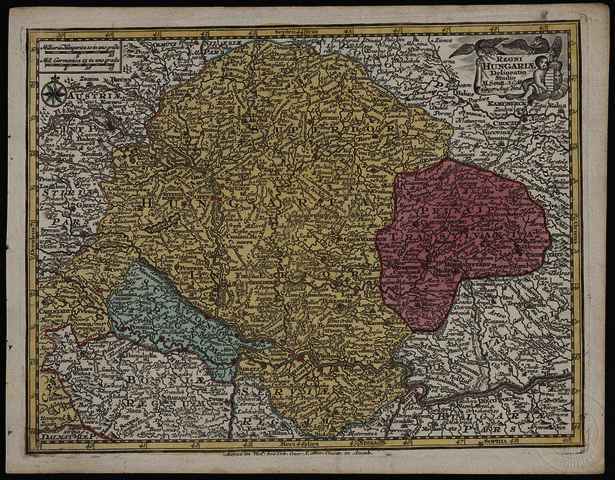


Seutter, Matthäus (Kartográfus): Regni Hungariæ delineatio. (1762)
![[img]](https://real-i.mtak.hu/18860/1/Terkep_244.jpg)
|
Kép
Terkep_244.jpg Letöltés (2MB) | Előzetes bemutató |
|
![[img]](https://real-i.mtak.hu/18860/2/Terkep_244_H.jpg)
|
Kép
Terkep_244_H.jpg Letöltés (893kB) | Előzetes bemutató |
| Tétel típus: | Térkép | ||||||
|---|---|---|---|---|---|---|---|
| További információk: | Kiadó / terjesztő: Anjezo im Verlag beÿ Tobias Conrad Lotter Raktári szám: Térkép 244 Egyéb cím: Regni Hungariae delineatio | ||||||
| Szabad kulcsszavak: | Szántai Lajos, Magyarország, általános térkép | ||||||
| Szakterület(ek): | G Geography. Anthropology. Recreation / földrajz, antropológia, kikapcsolódás > GA Mathematical geography. Cartography / földméréstan, geodézia, térképészet | ||||||
| Intézmények: | MTA Könyvtár és Információs Központ > MTA KIK Kézirattár és Régi Könyvek Gyűjteménye | ||||||
| Feltöltő: | Bálint Tóth | ||||||
| Alkotók: |
|
||||||
| Elhelyezés dátuma: | 26 Júni 2025 12:16 | ||||||
| Utolsó változtatás: | 12 Dec 2025 10:20 | ||||||
| URI: | https://real-i.mtak.hu/id/eprint/18860 |
Szerkesztés (Bejelentkezés szükséges)
 |
Tétel szekesztése |