


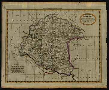
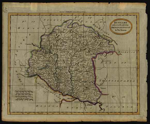
Bowen, Thomas (Egyéb): Hungary with part of the Adjoining Principalities &c. (1791)
![[img]](https://real-i.mtak.hu/18954/1/Terkep_300.jpg)
|
Kép
Terkep_300.jpg Letöltés (4MB) | Előzetes bemutató |
|
![[img]](https://real-i.mtak.hu/18954/2/Terkep_300_H.jpg)
|
Kép
Terkep_300_H.jpg Letöltés (3MB) | Előzetes bemutató |
| Tétel típus: | Térkép | ||||||
|---|---|---|---|---|---|---|---|
| További információk: | OSZK Földabrosz: A térkép csak a királyi Magyarországot ábrázolja, Erdély és Szlavónia nélkül Th. Bowen-t a befoglaló mű címlapján lévő felirat metszőként említi; Shirley 2004, G.BARL-1a leírása szerint Bowen készítette a mű térképeinek többségét Kiadó / terjesztő: printed by and for W. and J. Stratford Raktári szám: Térkép 300 | ||||||
| Szabad kulcsszavak: | Szántai Lajos, Magyarország, általános térkép | ||||||
| Szakterület(ek): | G Geography. Anthropology. Recreation / földrajz, antropológia, kikapcsolódás > GA Mathematical geography. Cartography / földméréstan, geodézia, térképészet | ||||||
| Intézmények: | MTA Könyvtár és Információs Központ > MTA KIK Kézirattár és Régi Könyvek Gyűjteménye | ||||||
| Feltöltő: | Bálint Tóth | ||||||
| Alkotók: |
|
||||||
| Elhelyezés dátuma: | 30 Júni 2025 08:48 | ||||||
| Utolsó változtatás: | 12 Dec 2025 10:17 | ||||||
| URI: | https://real-i.mtak.hu/id/eprint/18954 |
Szerkesztés (Bejelentkezés szükséges)
 |
Tétel szekesztése |
