


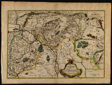
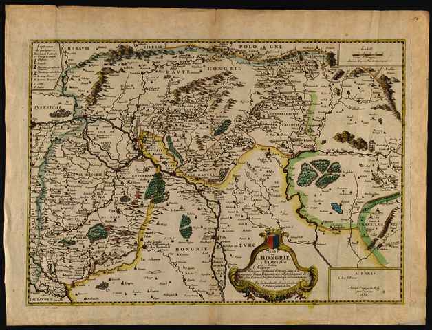
Duval, Pierre (Kartográfus): Carte de la Hongrie a l'Autriche. (1684)
![[img]](https://real-i.mtak.hu/19011/1/Terkep_357.jpg)
|
Kép
Terkep_357.jpg Letöltés (5MB) | Előzetes bemutató |
|
![[img]](https://real-i.mtak.hu/19011/2/Terkep_357_H.jpg)
|
Kép
Terkep_357_H.jpg Letöltés (3MB) | Előzetes bemutató |
| Tétel típus: | Térkép | ||||||
|---|---|---|---|---|---|---|---|
| További információk: | OSZK Földabrosz: Magyarország északi felének a térképe A térkép metszője F. de Lépine volt, metszői feliratát kb. 1675-ben törölték a nyomólemezről Kiadó / terjesztő: Chez l'Auteur Kiadás helye: Párizs Raktári szám: Térkép 357 | ||||||
| Szabad kulcsszavak: | Szántai Lajos, Magyarország, általános térkép | ||||||
| Szakterület(ek): | G Geography. Anthropology. Recreation / földrajz, antropológia, kikapcsolódás > GA Mathematical geography. Cartography / földméréstan, geodézia, térképészet | ||||||
| Intézmények: | MTA Könyvtár és Információs Központ > MTA KIK Kézirattár és Régi Könyvek Gyűjteménye | ||||||
| Feltöltő: | Bálint Tóth | ||||||
| Alkotók: |
|
||||||
| Elhelyezés dátuma: | 01 Júli 2025 07:54 | ||||||
| Utolsó változtatás: | 12 Dec 2025 10:24 | ||||||
| URI: | https://real-i.mtak.hu/id/eprint/19011 |
Szerkesztés (Bejelentkezés szükséges)
 |
Tétel szekesztése |
