


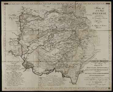
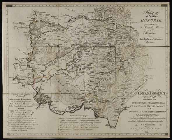
Kipferling, Karl Joseph (Kartográfus): Ober Ungern; iii.tes blatt Enthaltend die Torontaler, Temesvarer und Kraschower Gespannschaft nebst den Deutsch und Wallachisch-Illyrischen Grænz Regimentern. (1803)
![[img]](https://real-i.mtak.hu/19050/1/Terkep_398.jpg)
|
Kép
Terkep_398.jpg Letöltés (5MB) | Előzetes bemutató |
|
![[img]](https://real-i.mtak.hu/19050/2/Terkep_398_H.jpg)
|
Kép
Terkep_398_H.jpg Letöltés (1MB) | Előzetes bemutató |
| Tétel típus: | Térkép | ||||||
|---|---|---|---|---|---|---|---|
| További információk: | OSZK Földabrosz: Ábrázolt terület: Torontál, Temes és Krassó vármegye, valamint a Német- és Oláh-illír határőrkerület Kiadó / terjesztő: im Verlage des Kunst und Industrie Comptoir's Kiadás helye: Bécs Raktári szám: Térkép 398 | ||||||
| Szabad kulcsszavak: | Szántai Lajos, Bánát, általános térkép | ||||||
| Szakterület(ek): | G Geography. Anthropology. Recreation / földrajz, antropológia, kikapcsolódás > GA Mathematical geography. Cartography / földméréstan, geodézia, térképészet | ||||||
| Intézmények: | MTA Könyvtár és Információs Központ > MTA KIK Kézirattár és Régi Könyvek Gyűjteménye | ||||||
| Feltöltő: | Bálint Tóth | ||||||
| Alkotók: |
|
||||||
| Elhelyezés dátuma: | 01 Júli 2025 14:18 | ||||||
| Utolsó változtatás: | 12 Dec 2025 10:16 | ||||||
| URI: | https://real-i.mtak.hu/id/eprint/19050 |
Szerkesztés (Bejelentkezés szükséges)
 |
Tétel szekesztése |
