


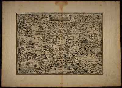
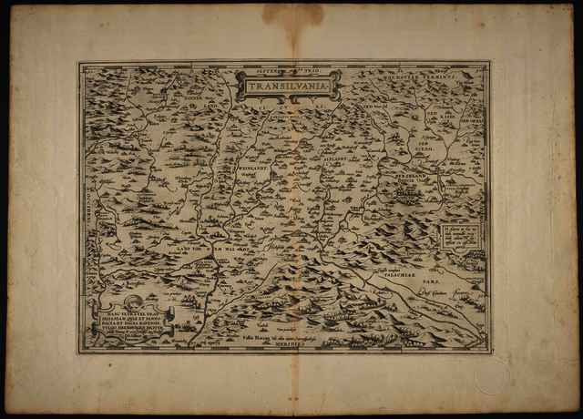
Ortelius, Abraham (Kartográfus): Transilvania hanc Ultra: vel Transilvaniam, qvae Panno-Dacia, et Dacia Ripensis, vvlgo Sibembvrgen dicitur, ędidit Viennȩ A.o 1566 Nobiliss. atq. Doctiss. Iōes Sābucus Pannonius. (1571)
![[img]](https://real-i.mtak.hu/19098/1/Terkep_443.jpg)
|
Kép
Terkep_443.jpg Letöltés (5MB) | Előzetes bemutató |
|
![[img]](https://real-i.mtak.hu/19098/2/Terkep_443_H.jpg)
|
Kép
Terkep_443_H.jpg Letöltés (3MB) | Előzetes bemutató |

| Tétel típus: | Térkép | ||||||
|---|---|---|---|---|---|---|---|
| További információk: | OSZK Földabrosz: A térképet A. Ortelius szerkesztette Zsámboki 1566-os Erdély térképe alapján. Kiadó / terjesztő: G. Coppen van Diest Raktári szám: Térkép 443 | ||||||
| Szabad kulcsszavak: | Szántai Lajos, Erdély, általános térkép | ||||||
| Szakterület(ek): | G Geography. Anthropology. Recreation / földrajz, antropológia, kikapcsolódás > GA Mathematical geography. Cartography / földméréstan, geodézia, térképészet | ||||||
| Intézmények: | MTA Könyvtár és Információs Központ > MTA KIK Kézirattár és Régi Könyvek Gyűjteménye | ||||||
| Feltöltő: | Bálint Tóth | ||||||
| Alkotók: |
|
||||||
| Elhelyezés dátuma: | 03 Júli 2025 08:06 | ||||||
| Utolsó változtatás: | 12 Dec 2025 10:28 | ||||||
| URI: | https://real-i.mtak.hu/id/eprint/19098 |
Szerkesztés (Bejelentkezés szükséges)
 |
Tétel szekesztése |
