


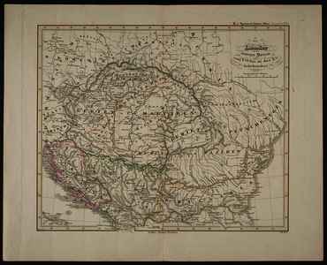
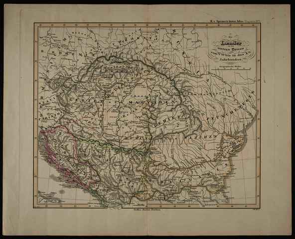
Spruner, Karl von (Kartográfus): Die Laender an der untern Donau vom Vten bis in das Xte Jahrhundert. (1855)
![[img]](https://real-i.mtak.hu/19170/1/Terkep_514.jpg)
|
Kép
Terkep_514.jpg Letöltés (2MB) | Előzetes bemutató |
|
![[img]](https://real-i.mtak.hu/19170/2/Terkep_514_H.jpg)
|
Kép
Terkep_514_H.jpg Letöltés (868kB) | Előzetes bemutató |
| Tétel típus: | Térkép | ||||||
|---|---|---|---|---|---|---|---|
| További információk: | OSZK Földabrosz: Magyarország és a vele DK-en szomszédos területek az 5-10. században Az 1. kiadás (1846) javított változata Kiadó / terjesztő: Justus Perthes Raktári szám: Térkép 514 | ||||||
| Szabad kulcsszavak: | Szántai Lajos, Kárpát-medence, Észak-Balkán, történelmi térkép | ||||||
| Szakterület(ek): | G Geography. Anthropology. Recreation / földrajz, antropológia, kikapcsolódás > GA Mathematical geography. Cartography / földméréstan, geodézia, térképészet | ||||||
| Intézmények: | MTA Könyvtár és Információs Központ > MTA KIK Kézirattár és Régi Könyvek Gyűjteménye | ||||||
| Feltöltő: | Bálint Tóth | ||||||
| Alkotók: |
|
||||||
| Elhelyezés dátuma: | 04 Júli 2025 10:58 | ||||||
| Utolsó változtatás: | 12 Dec 2025 10:10 | ||||||
| URI: | https://real-i.mtak.hu/id/eprint/19170 |
Szerkesztés (Bejelentkezés szükséges)
 |
Tétel szekesztése |
