


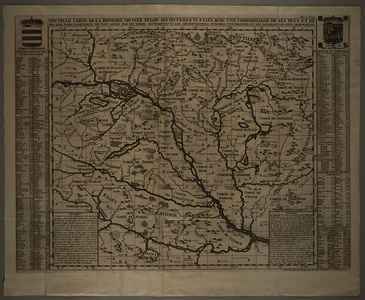
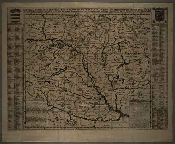
Chatelain, Zacharie (Egyéb): Nouvelle carte de la Hongrie, diviseé selon ses differents etats, avec une chronologie de ses ducs et de ses rois, dans la'quelle on voit aussi par des tables alphabetiques, les archeveschez, evechez, universitez, et les batailles les plus memorables. (1708)
![[img]](https://real-i.mtak.hu/19343/1/Terkep_566.jpg)
|
Kép
Terkep_566.jpg Letöltés (8MB) | Előzetes bemutató |
| Tétel típus: | Térkép | ||||||
|---|---|---|---|---|---|---|---|
| További információk: | Kiadó / terjesztő: L'Honoré-Chatelain Raktári szám: Térkép 566 | ||||||
| Szabad kulcsszavak: | Szántai Lajos, Magyarország, általános térkép, történelmi térkép | ||||||
| Szakterület(ek): | G Geography. Anthropology. Recreation / földrajz, antropológia, kikapcsolódás > GA Mathematical geography. Cartography / földméréstan, geodézia, térképészet | ||||||
| Intézmények: | MTA Könyvtár és Információs Központ > MTA KIK Kézirattár és Régi Könyvek Gyűjteménye | ||||||
| Feltöltő: | Bálint Tóth | ||||||
| Alkotók: |
|
||||||
| Elhelyezés dátuma: | 10 Júli 2025 14:17 | ||||||
| Utolsó változtatás: | 12 Dec 2025 10:23 | ||||||
| URI: | https://real-i.mtak.hu/id/eprint/19343 |
Szerkesztés (Bejelentkezés szükséges)
 |
Tétel szekesztése |
