


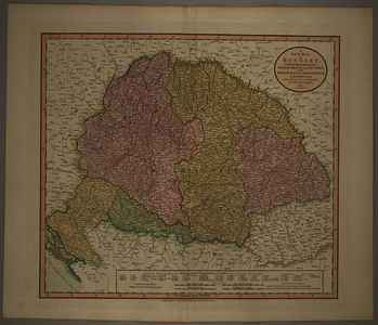
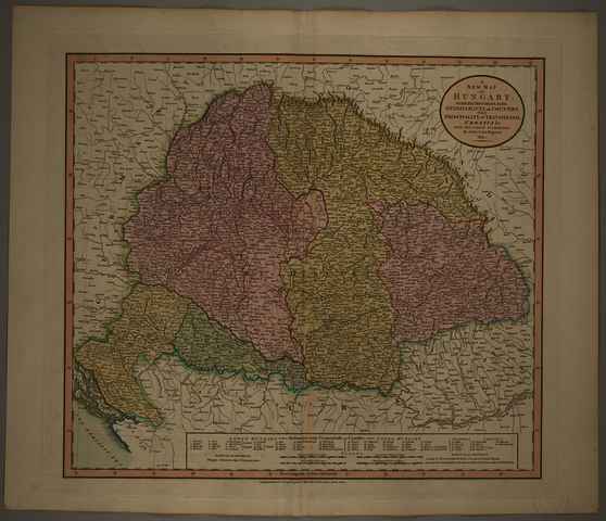
Cary, John (Kartográfus): A New Map of Hungary, with its divisions into Gespanschafts or counties; the principality of Transylvania, Croatia &c. from the latest authorities. (1811)
![[img]](https://real-i.mtak.hu/19359/1/Terkep_563.jpg)
|
Kép
Terkep_563.jpg Letöltés (7MB) | Előzetes bemutató |
| Tétel típus: | Térkép | ||||||
|---|---|---|---|---|---|---|---|
| További információk: | Kiadó / terjesztő: printed for J.Cary Raktári szám: Térkép 563 | ||||||
| Szabad kulcsszavak: | Szántai Lajos, Magyarország, általános térkép | ||||||
| Szakterület(ek): | G Geography. Anthropology. Recreation / földrajz, antropológia, kikapcsolódás > GA Mathematical geography. Cartography / földméréstan, geodézia, térképészet | ||||||
| Intézmények: | MTA Könyvtár és Információs Központ > MTA KIK Kézirattár és Régi Könyvek Gyűjteménye | ||||||
| Feltöltő: | Bálint Tóth | ||||||
| Alkotók: |
|
||||||
| Elhelyezés dátuma: | 11 Júli 2025 07:50 | ||||||
| Utolsó változtatás: | 12 Dec 2025 10:15 | ||||||
| URI: | https://real-i.mtak.hu/id/eprint/19359 |
Szerkesztés (Bejelentkezés szükséges)
 |
Tétel szekesztése |
