


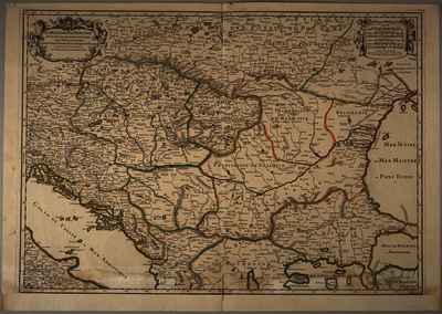
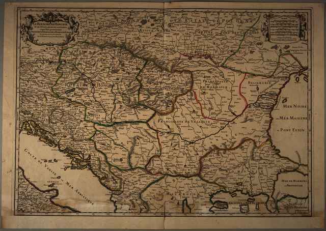
Sanson, Guillaume (Kartográfus): Le Royaume de Hongrie et les estats, qui en ont esté sujets et qui font presentement la partie septentrionale de la Turquie en Europe. (1706)
![[img]](https://real-i.mtak.hu/19542/1/Terkep_647.jpg)
|
Kép
Terkep_647.jpg Letöltés (8MB) | Előzetes bemutató |
|
![[img]](https://real-i.mtak.hu/19542/2/Terkep_647_H.jpg)
|
Kép
Terkep_647_H.jpg Letöltés (5MB) | Előzetes bemutató |
| Tétel típus: | Térkép | ||||||
|---|---|---|---|---|---|---|---|
| További információk: | Kiadó / terjesztő: Chez H. Iaillot Kiadás helye: Párizs Raktári szám: Térkép 647 | ||||||
| Szabad kulcsszavak: | Szántai Lajos, Magyarország, Észak-Balkán, általános térkép | ||||||
| Szakterület(ek): | G Geography. Anthropology. Recreation / földrajz, antropológia, kikapcsolódás > GA Mathematical geography. Cartography / földméréstan, geodézia, térképészet | ||||||
| Intézmények: | MTA Könyvtár és Információs Központ > MTA KIK Kézirattár és Régi Könyvek Gyűjteménye | ||||||
| Feltöltő: | Bálint Tóth | ||||||
| Alkotók: |
|
||||||
| Elhelyezés dátuma: | 04 Aug 2025 07:25 | ||||||
| Utolsó változtatás: | 12 Dec 2025 10:23 | ||||||
| URI: | https://real-i.mtak.hu/id/eprint/19542 |
Szerkesztés (Bejelentkezés szükséges)
 |
Tétel szekesztése |
