


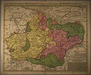
Jaillot, Alexis-Hubert (Kartográfus): Principauté de Transilvanie Divisée en Cinq Nations, Subdivisée en Quartiers et Comtez. (1725)
![[img]](https://real-i.mtak.hu/19550/1/terkep_651.jpg)
|
Kép
terkep_651.jpg Letöltés (7MB) | Előzetes bemutató |
|
![[img]](https://real-i.mtak.hu/19550/2/terkep_651_H.jpg)
|
Kép
terkep_651_H.jpg Letöltés (3MB) | Előzetes bemutató |
| Tétel típus: | Térkép | ||||||
|---|---|---|---|---|---|---|---|
| További információk: | OSZK Földabrosz: Domborzat halmos ábrázolással, helyenként névírással is Kiadó / terjesztő: Chez R. & J. Ottens Raktári szám: Térkép 651 | ||||||
| Szabad kulcsszavak: | Szántai Lajos, Erdély, általános térkép | ||||||
| Szakterület(ek): | G Geography. Anthropology. Recreation / földrajz, antropológia, kikapcsolódás > GA Mathematical geography. Cartography / földméréstan, geodézia, térképészet | ||||||
| Intézmények: | MTA Könyvtár és Információs Központ > MTA KIK Kézirattár és Régi Könyvek Gyűjteménye | ||||||
| Feltöltő: | Bálint Tóth | ||||||
| Alkotók: |
|
||||||
| Elhelyezés dátuma: | 04 Aug 2025 08:07 | ||||||
| Utolsó változtatás: | 12 Dec 2025 10:22 | ||||||
| URI: | https://real-i.mtak.hu/id/eprint/19550 |
Szerkesztés (Bejelentkezés szükséges)
 |
Tétel szekesztése |
