


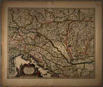
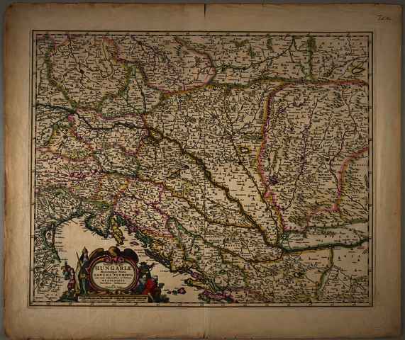
Jonghe, Clement de (Egyéb): Totius Regni Hungariae Maximaeque partis Danubii Fluminis una cum adjacentibus et finitimis Regionibus Novissima Delineatio. (1663)
![[img]](https://real-i.mtak.hu/19554/1/Terkep_654.jpg)
|
Kép
Terkep_654.jpg Letöltés (7MB) | Előzetes bemutató |
|
![[img]](https://real-i.mtak.hu/19554/2/Terkep_654_H.jpg)
|
Kép
Terkep_654_H.jpg Letöltés (4MB) | Előzetes bemutató |
| Tétel típus: | Térkép | ||||||
|---|---|---|---|---|---|---|---|
| További információk: | Kiadó / terjesztő: C. Ionge Raktári szám: Térkép 654 | ||||||
| Szabad kulcsszavak: | Szántai Lajos, Magyarország, általános térkép | ||||||
| Szakterület(ek): | G Geography. Anthropology. Recreation / földrajz, antropológia, kikapcsolódás > GA Mathematical geography. Cartography / földméréstan, geodézia, térképészet | ||||||
| Intézmények: | MTA Könyvtár és Információs Központ > MTA KIK Kézirattár és Régi Könyvek Gyűjteménye | ||||||
| Feltöltő: | Bálint Tóth | ||||||
| Alkotók: |
|
||||||
| Elhelyezés dátuma: | 04 Aug 2025 08:42 | ||||||
| Utolsó változtatás: | 12 Dec 2025 10:26 | ||||||
| URI: | https://real-i.mtak.hu/id/eprint/19554 |
Szerkesztés (Bejelentkezés szükséges)
 |
Tétel szekesztése |
