


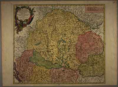
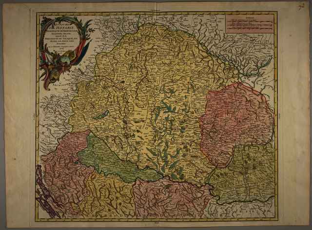
Robert, Gilles (Egyéb): Royaume de Hongrie, principauté de Transilvanie, Sclavonie, Croatie, et partie de la principauté de Valaquie, de la Bosnie, de la Servie et de la Bulgarie. (1751)
![[img]](https://real-i.mtak.hu/19622/1/Terkep_707.jpg)
|
Kép
Terkep_707.jpg Letöltés (8MB) | Előzetes bemutató |
|
![[img]](https://real-i.mtak.hu/19622/2/Terkep_707_H.jpg)
|
Kép
Terkep_707_H.jpg Letöltés (4MB) | Előzetes bemutató |
| Tétel típus: | Térkép | ||||||
|---|---|---|---|---|---|---|---|
| További információk: | OSZK Földabrosz: A térképet G. Robert készítette (aki a de Vaugondy nevet nem használta), fia, D. Robert de Vaugondy és A. Ch. Boudet az Atlas universel társkiadói voltak Kiadó / terjesztő: Gilles Robert Kiadás helye: Párizs Raktári szám: Térkép 707 | ||||||
| Szabad kulcsszavak: | Szántai Lajos, Magyarország, általános térkép | ||||||
| Szakterület(ek): | G Geography. Anthropology. Recreation / földrajz, antropológia, kikapcsolódás > GA Mathematical geography. Cartography / földméréstan, geodézia, térképészet | ||||||
| Intézmények: | MTA Könyvtár és Információs Központ > MTA KIK Kézirattár és Régi Könyvek Gyűjteménye | ||||||
| Feltöltő: | Bálint Tóth | ||||||
| Alkotók: |
|
||||||
| Elhelyezés dátuma: | 05 Aug 2025 14:12 | ||||||
| Utolsó változtatás: | 12 Dec 2025 10:20 | ||||||
| URI: | https://real-i.mtak.hu/id/eprint/19622 |
Szerkesztés (Bejelentkezés szükséges)
 |
Tétel szekesztése |
