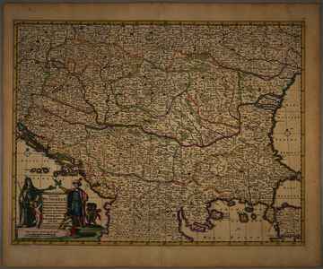
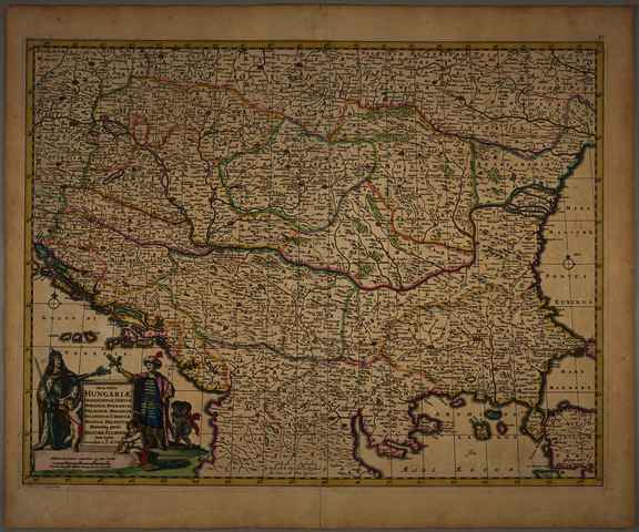
Nova totius Hungariæ, Transilvaniæ, Serviæ, Romaniæ, Bulgariæ, Walachiæ, Moldaviæ, Sclavoniæ, Croatiæ, Bosniæ, Dalmatiæ maximæq. partis Danubii Fluminis descriptio
Wit, Frederick de
(Kartográfus):
Nova totius Hungariæ, Transilvaniæ, Serviæ, Romaniæ, Bulgariæ, Walachiæ, Moldaviæ, Sclavoniæ, Croatiæ, Bosniæ, Dalmatiæ maximæq. partis Danubii Fluminis descriptio.
(1666)
| Tétel típus: |
Térkép
|
| További információk: |
Kiadó / terjesztő: by Frederick de Wit
Raktári szám: Térkép 786
Egyéb cím: Nova totius Hungariae, Transilvaniae, Serviae, Romaniae, Bulgariae, Walachiae, Moldaviae, Sclavoniae, Croatiae, Bosniae, Dalmatiae maximaeq. partis Danubii Fluminis descriptio |
| Szabad kulcsszavak: |
Szántai Lajos, Magyarország, Észak-Balkán, általános térkép |
| Szakterület(ek): |
G Geography. Anthropology. Recreation / földrajz, antropológia, kikapcsolódás > GA Mathematical geography. Cartography / földméréstan, geodézia, térképészet |
| Intézmények: |
MTA Könyvtár és Információs Központ > MTA KIK Kézirattár és Régi Könyvek Gyűjteménye |
| Feltöltő: |
Bálint Tóth
|
| Alkotók: |
| Közreműködés típusa | Név | Alkotó azonosító |
|---|
| Kartográfus | Wit, Frederick de | MEGHATÁROZATLAN |
|
| Elhelyezés dátuma: |
12 Aug 2025 12:43 |
| Utolsó változtatás: |
25 Aug 2025 14:21 |
| URI: |
https://real-i.mtak.hu/id/eprint/19760 |
Szerkesztés (Bejelentkezés szükséges)
 |
Tétel szekesztése |
|


![[img]](https://real-i.mtak.hu/19760/1/Terkep_786.jpg)
![[img]](https://real-i.mtak.hu/19760/2/Terkep_786_H.jpg)
