


Senex, John (Kartográfus): A new map of the Kingdom of Hungary And of the Countries, Provinces &c. Bordering thereupon, with their respective Bannats, Counties, Sanjiacships, Mountains, Passes, Post Roads, Cities &c. as also the Places where Battels have been Fought and at what Time,. (1752)
![[img]](https://real-i.mtak.hu/19795/1/Terkep_823.jpg)
|
Kép
Terkep_823.jpg Letöltés (16MB) | Előzetes bemutató |
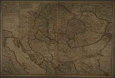
| Tétel típus: | Térkép | ||||||
|---|---|---|---|---|---|---|---|
| További információk: | Kiadó / terjesztő: Printed for T. Bowles ... John Bowles & Son, ... Rob.t Sayer Raktári szám: Térkép 823 | ||||||
| Szabad kulcsszavak: | Szántai Lajos, Magyarország, Észak-Balkán, általános térkép | ||||||
| Szakterület(ek): | G Geography. Anthropology. Recreation / földrajz, antropológia, kikapcsolódás > GA Mathematical geography. Cartography / földméréstan, geodézia, térképészet | ||||||
| Intézmények: | MTA Könyvtár és Információs Központ > MTA KIK Kézirattár és Régi Könyvek Gyűjteménye | ||||||
| Feltöltő: | Bálint Tóth | ||||||
| Alkotók: |
|
||||||
| Elhelyezés dátuma: | 14 Aug 2025 07:33 | ||||||
| Utolsó változtatás: | 14 Aug 2025 07:43 | ||||||
| URI: | https://real-i.mtak.hu/id/eprint/19795 |
Szerkesztés (Bejelentkezés szükséges)
 |
Tétel szekesztése |
