


MTA Ökológiai Botanika Kutatóintézete, MÉTA Munkacsoport (Egyéb): I1 – Üde természetes pionír növényzet = I1 – Amphibious communities on river gravel and sand banks. (2008)
![[img]](http://real-i.mtak.hu/495/1/i1.jpg)
|
Kép
i1.jpg Letöltés (1MB) | Előzetes bemutató |
|
![[img]](http://real-i.mtak.hu/style/images/fileicons/other.png) |
Egyéb (Metaadat)
i1.xml Letöltés (4kB) |
Tartalmi kivonat
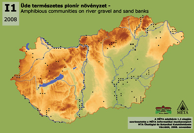
I1 – Üde természetes pionír növényzet: Folyók medrében és hullámterén, ritkábban mocsarakban, belvizes mélyedésekben vízborítást követően szabaddá váló felszíneken kifejlődő, döntő többségében egyéves, alacsony növekedésű, törpekákás fajok alkotta pionír növényzet. Rizsföldeken és belvizes években szántókon is előfordulhat. Az állományok kiterjedése gyakran 1 m2-nél is kisebb. Fajai nem ruderálisak! Igen sok országosan ritka, védett, veszélyeztetett fajt találunk ezeken a termőhelyeken (pl. Astragalus contortuplicatus, Carex bohemica, Elatine spp., Lindernia procumbens). Jellemzőek lehetnek a különböző Cyperus fajok, az apró termetű Juncus fajok, a Limosella aquatica, az Eleocharis acicularis és az Eleocharis ovata, a Gnaphalium uliginosum, a Cyperus flavescens, a Heliotropium supinum, a Schoenoplectus supinus vagy a Verbena supina. Nem következetesen dokumentált élőhely. A belvizes szántók fajgazdag részei általában kimaradtak a térképezésből (a bejárás módja, valamint a száraz nyarak miatt). Kétszáz hektárnyit térképeztünk, de ez belvizes években sokszorosára nőhet, míg száraz években az élőhely a folyók parti zónájára húzódik vissza. Csak célirányos, megfelelő évben végzett térképezéssel dokumentálhatók állományai. I1 – Amphibious communities on river gravel and sand banks: Pioneer, low, mainly annual vegetation of Nanocyperion species. It grows on bare surfaces along rivers and on floodplains, sometimes in marshes and waterlogged depressions. It can occur on rice fields and in wet years also on arable fields. The extension of the stands is often smaller then 1 m2. Their species are not ruderal, numerous nationally rare, protected and endangered species can be found on these sites (e.g. Astragalus contortuplicatus, Carex bohemica, Elatine spp., Lindernia procumbens). Other typical species are: Cyperus and Juncus species, Limosella aquatica, Eleocharis acicularis and E. ovata, Gnaphalium uliginosum, Heliotropium supinum, Schoenoplectus supinus or Verbena supina. The habitat is not consistently documented. Species rich parts of flooded arable fields were not mapped (by reason of the survey method and the dry summers). We documented altogether 200 ha, but this amount can multiply in wet years, while the community withdraws to the bank zone of the rivers in dry years. The stands can be documented only with detailed and focussed mapping in wet years.
| Tétel típus: | Térkép | ||||||
|---|---|---|---|---|---|---|---|
| További információk: | Magyarországi élőhelyek elterjedési térképe sorozat tagja. | Magyar Digitális Képkönyvtár projekt (2009) | ||||||
| Szabad kulcsszavak: | növényzet, elterjedés, ökológia | ||||||
| Szakterület(ek): | G Geography. Anthropology. Recreation / földrajz, antropológia, kikapcsolódás > G Geography (General) / Földrajz általában Q Science / természettudomány > QH Natural history / természetrajz > QH301 Biology / biológia |
||||||
| Intézmények: | MTA Ökológiai és Botanikai Kutatóintézet | ||||||
| Feltöltő: | Zsolt Székely | ||||||
| Alkotók: |
|
||||||
| Elhelyezés dátuma: | 17 Aug 2021 08:28 | ||||||
| Utolsó változtatás: | 12 Okt 2021 07:27 | ||||||
| URI: | http://real-i.mtak.hu/id/eprint/495 |
Szerkesztés (Bejelentkezés szükséges)
 |
Tétel szekesztése |
