


MTA Ökológiai Botanika Kutatóintézete, MÉTA Munkacsoport (Egyéb): I4 - Árnyéktűrő nyílt sziklanövényzet = I4 – Open vegetation of shadowed rocks. (2008)
![[img]](http://real-i.mtak.hu/497/1/i4.jpg)
|
Kép
i4.jpg Letöltés (956kB) | Előzetes bemutató |
|
![[img]](http://real-i.mtak.hu/style/images/fileicons/other.png) |
Egyéb (Metaadat)
i4.xml Letöltés (4kB) |
Tartalmi kivonat
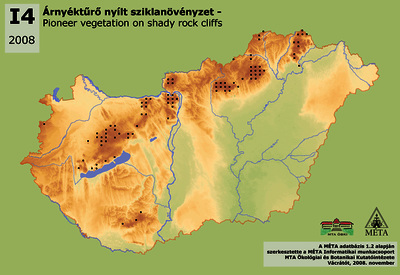
I4 - Árnyéktűrő nyílt sziklanövényzet: Hegyvidékeink „járhatatlan” sziklakibúvásain, törmeléklejtőin, árnyas, üde sziklafalai (általában északias kitettségben) előforduló, nyílt, pionír, gyakran fejlett mohaszintű élőhely. Az évelő fűfélék, cserje- és fafajok tömeges elszaporodásához, - sziklagyepek, cserjések, erdők kialakulásához – az abiotikus adottságok, a talaj hiánya nem teremtenek megfelelő feltételeket. A sziklafalakon való megjelenés miatt az élőhely kiterjedése nehezen értelmezhető, elterjedését ezért inkább előfordulási gyakoriságával lehet jellemezni. Leggyakoribb az Északi-középhegységben (190 előfordulás), ahol legnagyobb számban a Bükkben, a Mátrában, a Sátor-hegységben és a Börzsönyben találjuk, de előfordul az Aggteleki-karszton és a Heves-Borsodi-dombvidéken is. A Dunántúli-középhegységben ritkább (mintegy 60 előfordulás), ahol szintén a magasabb részeken gyakoribb (Bakony, Pilis, Visegrádi-hegység), máshol jóval ritkább (Keszthelyi-hegység, Balaton-felvidék, Gerecse, Budai-hegység). Néhány helyen előfordul a Mecsekben és egy előfordulását találtuk a Kőszegi-hegységben is. I4 – Open vegetation of shadowed rocks: These, characteristically open, mesic, pioneer communities – often with well-developed moss layer – occur on shadowed rock outcrops, rock cliffs, screes, periglacial block streams (usually facing to the north). The abiotic parameters and the lack of the soil do not offer suitable conditions for the mass spread of perennial grass, shrub, and tree species, and in this way neither to the evolution of rock grasslands, thickets and forests. Due to the occurrences on rock cliffs, the extension of the habitat can hardly be interpreted; consequently, for this habitat also the frequency of occurrences is a better descriptor of its distribution than the extension in hectare. It is most common in the Északi-középhegység (190 occurrences), it can be found with the greatest number in Bükk, Mátra, Sátor-hegység and Börzsöny, but occurs also on Aggteleki-karszt and on the Heves-Borsodi-dombság. More infrequent in the Dunántúli-középhegység (approx. 60 stands), mainly in the highest parts (Bakony, Pilis, Visegrádi-hegység), and very rare in other regions (Keszthelyi-hegység, Balaton-felvidék, Gerecse, Budai-hegység). There are some stands in Mecsek, and only one stand was found in the Kőszegi-hegység.
| Tétel típus: | Térkép | ||||||
|---|---|---|---|---|---|---|---|
| További információk: | Magyarországi élőhelyek elterjedési térképe sorozat tagja. | Magyar Digitális Képkönyvtár projekt (2009) | ||||||
| Szabad kulcsszavak: | növényzet, elterjedés, ökológia | ||||||
| Szakterület(ek): | G Geography. Anthropology. Recreation / földrajz, antropológia, kikapcsolódás > G Geography (General) / Földrajz általában Q Science / természettudomány > QH Natural history / természetrajz > QH301 Biology / biológia |
||||||
| Intézmények: | MTA Ökológiai és Botanikai Kutatóintézet | ||||||
| Feltöltő: | Zsolt Székely | ||||||
| Alkotók: |
|
||||||
| Elhelyezés dátuma: | 17 Aug 2021 08:36 | ||||||
| Utolsó változtatás: | 12 Okt 2021 07:29 | ||||||
| URI: | http://real-i.mtak.hu/id/eprint/497 |
Szerkesztés (Bejelentkezés szükséges)
 |
Tétel szekesztése |
