


MTA Ökológiai Botanika Kutatóintézete, MÉTA Munkacsoport (Egyéb): RC - Keményfás jellegtelen vagy telepített egyéb erdők = RC – Uncharacteristic hardwood forests and plantations. (2008)
![[img]](http://real-i.mtak.hu/542/1/rc.jpg)
|
Kép
rc.jpg Letöltés (1MB) | Előzetes bemutató |
|
![[img]](http://real-i.mtak.hu/style/images/fileicons/other.png) |
Egyéb (Metaadat)
rc.xml Letöltés (4kB) |
Tartalmi kivonat
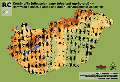
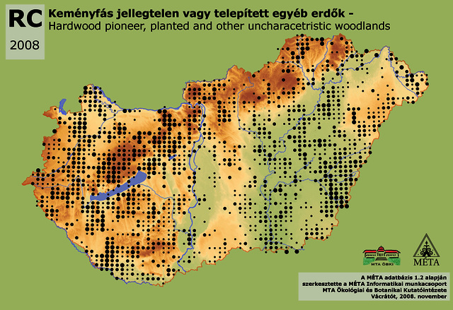
RC - Keményfás jellegtelen vagy telepített egyéb erdők: Olyan kemény fájú őshonos fajok uralta, többnyire elegyetlen, erdei lágyszárúakban szegényes erdők gyűjtőcsoportja, amelyek más csoportba [J-L-ig] nem sorolhatók be biztosan. Rendszerint szántókra, gyepekre telepített, vagy erdők helyén kialakított faállományok, kivételesen gyepeken, felhagyott szántókon spontán kialakult vagy bizonytalan származású erdők. Leggyakoribb fafajaik a cser- és kocsányos tölgy (Quercus cerris, Q. robur), a magas és magyar kőris (Fraxinus excelsior, F. angustifolia ssp. pannonica). Összes kiterjedése meghaladja a 80000 ha-t. Legnagyobb kiterjedésben az Alföldön (30000 ha) és a Dunántúli- középhegységben (17500 ha) találni. Kisebb a kiterjedése a Dél-Dunántúlon (12500 ha) és a Nyugat-Dunántúlon (8500 ha). Legkisebb kiterjedésben az Északi-középhegységben (6500 ha) és a Kisalföldön (5000 ha) fordul elő. Alapvetően ember által létrehozott élőhelytípus, amely az országban csaknem egyenletesen mindenhol megtalálható. RC – Uncharacteristic hardwood forests and plantations: Forests dominated generally by only one native hardwood tree species. They have poor herb layer and their classification to another natural habitat type [from J to N] is problematic. Plantations on arable fields, on grasslands, and on the place of former (semi-)natural forests consist generally this group, but infrequently spontaneous woodlands or forests of uncertain origin on grasslands and on old-fields also belong to this habitat type. Most frequent dominating tree species are the Quercus cerris and Q. robur, the Fraxinus excelsior and F. angustifolia subsp. pannonica. The total area of the habitat is more than 80000 ha. It occurs with the largest extension on Alföld (30000 ha) and in the Dunántúli-középhegység (17500 ha). It covers smaller area on Dél-Dunántúl (12500 ha) and on Nyugat-Dunántúl (8500 ha). It can be found with the smallest amount in the Északi-középhegység (6500 ha) and on Kisalföld (5000 ha).
| Tétel típus: | Térkép | ||||||
|---|---|---|---|---|---|---|---|
| További információk: | Magyarországi élőhelyek elterjedési térképe sorozat tagja. | Magyar Digitális Képkönyvtár projekt (2009) | ||||||
| Szabad kulcsszavak: | növényzet, elterjedés, ökológia | ||||||
| Szakterület(ek): | G Geography. Anthropology. Recreation / földrajz, antropológia, kikapcsolódás > G Geography (General) / Földrajz általában Q Science / természettudomány > QH Natural history / természetrajz > QH301 Biology / biológia |
||||||
| Intézmények: | MTA Ökológiai és Botanikai Kutatóintézet | ||||||
| Feltöltő: | Zsolt Székely | ||||||
| Alkotók: |
|
||||||
| Elhelyezés dátuma: | 17 Aug 2021 13:16 | ||||||
| Utolsó változtatás: | 12 Okt 2021 08:53 | ||||||
| URI: | http://real-i.mtak.hu/id/eprint/542 |
Szerkesztés (Bejelentkezés szükséges)
 |
Tétel szekesztése |
