


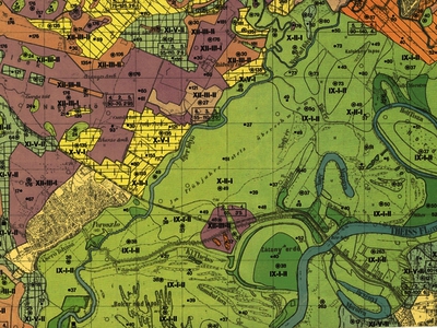
Zakariás, Jenő és Kreybig, Lajos (Kartográfus, Kartográfus): Poroszló : Átnézetes talajismereti térkép. (1934)
![[img]](http://real-i.mtak.hu/913/1/b317_gistt_zakarias_%20poroszlo_talajterkep.JPG)
|
Kép
b317_gistt_zakarias_ poroszlo_talajterkep.JPG Letöltés (524kB) | Előzetes bemutató |
| Tétel típus: | Térkép | |||||||||
|---|---|---|---|---|---|---|---|---|---|---|
| További információk: | Kreybig Lajos (agrokémikus, talajkutató, MTA Tagja, megszervezte és vezette az ország új talajismereti térképezését) (1879-1956) | |||||||||
| Szabad kulcsszavak: | talajtan -- talajtérképezés, felvételezés, talajinformációs rendszer -- nyomtatott térkép | |||||||||
| Szakterület(ek): | Q Science / természettudomány > QE Geology / földtudományok S Agriculture / mezőgazdaság > S1 Agriculture (General) / mezőgazdaság általában > S590 Soill / Talajtan |
|||||||||
| Intézmények: | MTA TAK Talajtani és Agrokémiai Kutatóintézet | |||||||||
| Feltöltő: | László Sallai-Tóth | |||||||||
| Alkotók: |
|
|||||||||
| Elhelyezés dátuma: | 16 Szep 2021 11:40 | |||||||||
| Utolsó változtatás: | 16 Szep 2021 11:40 | |||||||||
| URI: | http://real-i.mtak.hu/id/eprint/913 |
Szerkesztés (Bejelentkezés szükséges)
 |
Tétel szekesztése |
